Weather
The term ‘weather’ refers to the local, short-term characteristics of the atmosphere of a particular place. Weather events occur regularly on Earth and include wind, rain, thunderstorms, hail, snow and fog. These events are the result of different masses of air coming together. When air masses meet, differences in temperature, pressure and the amount of moisture in the air might lead to the formation of clouds and precipitation in the form of rain, hail or snow. Average weather conditions tell us about the climate of a particular place.
The term ‘climate’ refers to the long-term or prevailing weather conditions in a particular place. For example, a desert location that has no rain for most of the year might be described as having an arid (dry) climate, even if the weather on a certain day is wet or rainy. To know about the climate of a particular place, we have to observe and record the weather over a long period of time; this gives us an idea of the most common weather conditions, and what to expect in the future. The science of studying the atmosphere and predicting the weather is known as meteorology.
A very important part of meteorology is recording atmospheric data over long periods. Meteorologists use this data to detect patterns in the weather and climate trends. Long-term records not only enable scientists to know about the past, but also help them to better predict weather patterns in the future.
Meteorologists use a wide variety of instruments for observing the weather, including:
- thermometers to measure air temperature
- barometers to measure air pressure
- anemometers to measure wind speed
- hygrometers to measure air humidity—how much moisture (water vapour) is in the air
- weather radars to detect approaching rainfall
- weather satellites to monitor cloud cover, surface temperatures of land and sea and other data about the atmosphere.
Clouds
Clouds are formed when warm moist air rises to where it is cooler and the pressure in the atmosphere is lower. As the warm moist air cools (all gases cool when they expand under low pressure), some of the water vapour in the air changes from a gas to a liquid (condenses), forming tiny water droplets. A mass of billions of these tiny suspended water droplets is visible as a cloud.
"Cumulus humilis clouds" by Toby Hudson (Wikimedia Commons) licensed under CC BY SA 3.0
Rain develops when water droplets join together and become too heavy to remain in the cloud, suspended in air currents. Gravity pulls the droplets towards the surface of the Earth, where they fall as precipitation.
When estimating cloud cover, meteorologists divide the sky into eighths. If they estimate that eight-eighths are covered by clouds, they describe the sky as having total cloud cover. If they estimate that zero parts are covered, they describe the sky as being clear. In weather forecasts, the terminology used is simpler: clear (no cloud), sunny (little chance of the Sun being obscured by cloud), cloudy (more cloud than clear sky) and overcast (total cloud cover).
Temperature
Temperature is the degree of hotness. It is a measure of the intensity of heat rather than the amount of heat. When meteorologists discuss temperature, they are specifically referring to air temperature.
There are three temperature scales used to accurately measure and describe temperature. Australia and most other countries use the Celsius (sometimes called centigrade) scale. In this scale, zero degrees Celsius (0ºC) is the freezing point of water, and 100 degrees Celsius (100ºC) is the boiling point of water. Points below freezing are quoted as negative numbers.
In the Fahrenheit scale (still used in the United States), 32 degrees Fahrenheit is the freezing point of water and 212 degrees Fahrenheit is the boiling point of water.
In the Kelvin (also known as the ‘absolute’) scale, zero degrees is ‘absolute zero’, which is the point at which there is no heat whatsoever in the object being measured and that is as low as temperature can get. In this scale, 273 degrees Kelvin is the freezing point of water and 373 degrees Kelvin is the boiling point. There are no negative absolute temperatures.
The Kelvin scale is most often used by physicists and chemists because certain relationships are simpler to describe when absolute temperature is used. The Celsius and Fahrenheit scales are commonly used to measure everyday temperature.
Wind
Wind is the movement of air over the surface of the Earth. Winds are driven by the heat from the Sun, which warms the air and causes it to rise. Where warm air rises, cool air flows in to take its place. This motion is felt on the Earth’s surface as wind. Wind is described in terms of its strength or speed and the compass direction from which it is blowing. Wind speed can be expressed in kilometres per hour, metres per second, knots, or as a force on the Beaufort Scale.
When weather forecasters describe the wind they usually include information about both its strength and direction. For example, a fresh south-westerly wind is a wind blowing from the south-west at an average speed of 30–39 kilometres per hour (the speed of ‘fresh breeze’ on the Beaufort Scale). The term ‘gusty’ is often used in weather reports to describe winds that have sudden increases above the average speed for short periods of time.
Knowledge of wind strength is useful for recreational activities like sailing, the safety of people working in high places or at sea and for forecasting the movement of pollution and smoke from bushfires to populated areas.

On this page:
- Browse these tabs to learn about powerful scientific ideas in earth and space sciences.
Seasons
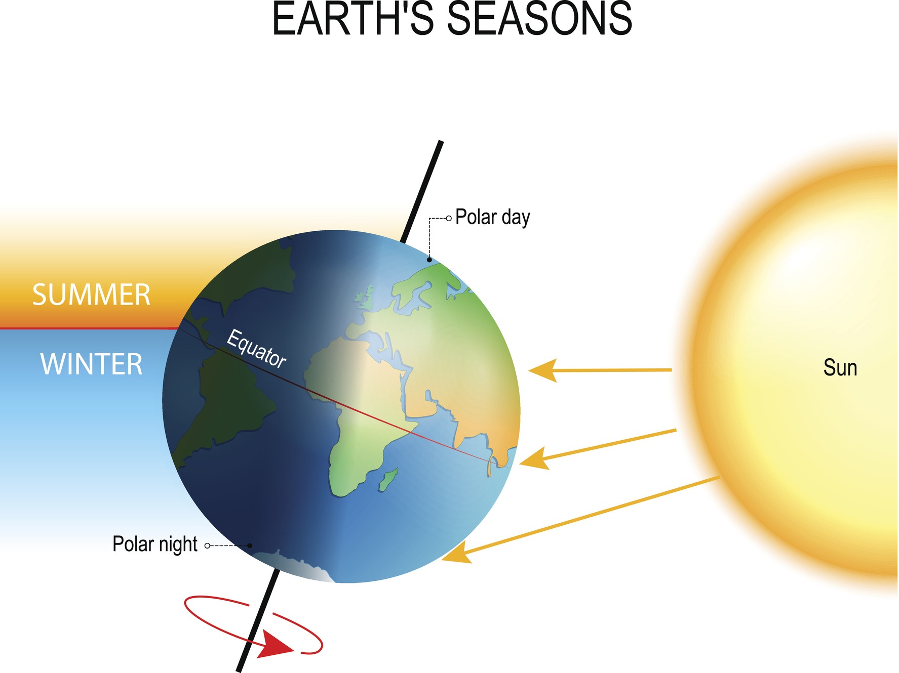
Seasons are caused by three phenomena:
- the revolution of the Earth around the Sun once per year,
- the tilt of the Earth’s axis of 23.5 degrees relative to the perpendicular to the plane of the orbit around the Sun, and
- the location on Earth.
Countries on or close to the equator experience very little seasonal temperature variation because the Sun’s rays are very direct all year round, the tilt of the axis having little effect at the centre of the globe. The poles experience the most extreme seasons, with approximately six months of sunlight and six months of darkness and the greatest differences in angle of the Sun’s rays.
When the Earth is tilted towards the sun, the days are longer and nights shorter. The greater time for direct sunlight exposure heats the ground and atmosphere.
Different places and cultures in Australia observe different seasons. Being such a large country, with locations close to the equator in the north and closer to Antarctica in the south, many locations in Australia experience the seasons differently.
Some people in northern tropical areas of Australia identify two seasons: the wet and the dry. Others, such as the Nunggubuyu people, identify five seasons. In the south of Australia people commonly identify four seasons, each lasting approximately three months: spring, summer, autumn and winter.
Official dates of starting seasons vary across the globe. For example, the start date is close to the 20th day of the month for many European countries but always on the 1st day of the month in Australia. Seasonal changes are variable and depend on many factors.
On this page:
- Browse these tabs to learn about powerful scientific ideas in earth and space sciences.
Soils, rocks and minerals
Rocks and minerals
The outer crust of the Earth is made up of rock. In places the rock is covered by soil or water. This outer shell isn’t rigid and events such as earthquakes and volcanos help shape the landscape as they impact on the rocky layer and bring new material to the surface. The word ‘rock’ in common usage can refer to large cliffs and boulders as well as to small stones or pebbles. Scientists are more precise when they use the word ‘rock’ and understand it to mean an aggregate of minerals.
A rock is made of mineral materials in a solid state. Geologists use features such as the mineral composition and the shape, size and orientation of the fragments in the rock to classify rocks according to their origin. Both the composition of the minerals and the circumstances under which it was formed determine the features and properties of the rock.
Some commonly measured properties include:
- Density: the ratio of mass to volume for a material. Measuring density tells you if a material is heavy for its size. A rock that floats in water is less dense than water.
- Hardness: how resistant solid matter is to various kinds of permanent shape change when a force is applied. A common measure is to see whether the rock scratches different surfaces to determine if it is harder than the material it is being scratched against. Hardness is usually measured for minerals rather than rocks. The hardest mineral known is diamond whilst the softest is talc. The Mohs hardness scale developed by Fredrich Mohs ranks 10 common minerals based on their hardness.
Rocks are made up of a variety of minerals put together in different ways resulting in different colours and textures. Geologists classify rocks based on their texture and composition. The texture of a rock refers to the size, shape and arrangement of the constituent mineral grains, whilst the composition of a rock is based on the chemical composition of the minerals it contains. Minerals have physical properties, such as cleavage, hardness, specific gravity, colour and streak (the colour of the powdered mineral).
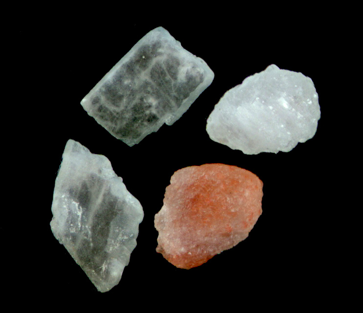
These rocks are made up of mineral salts.
The term ‘property’ refers to an attribute of an object or material, normally used to describe attributes common to a group. In the case of rocks and soils it is the minerals they are composed of that exhibit these properties. For ease of understanding it is suggested that the term ‘feature’ is used to allow students to describe aspects of an object or material. Typically, a student description of a rock might mention some properties of minerals (hard, jagged, colour) and many that are not properties (big, small, round, smooth).
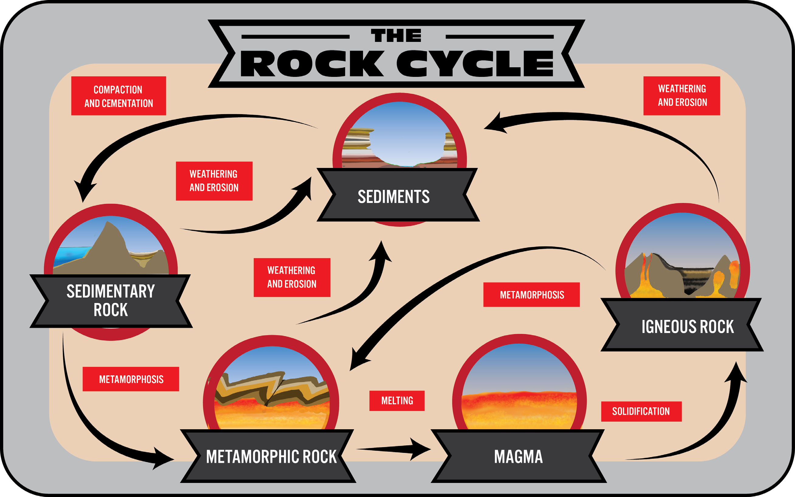
Geologists (scientists who study the origin, history and structure of the earth) classify rocks into three basic types depending on the way that they were formed: igneous, sedimentary and metamorphic.
- Igneous rocks are formed from the solidification of the minerals found in magma.
- Sedimentary rocks are formed at the Earth’s surface from the accumulation and consolidation of sediment.
- Metamorphic rocks are formed from pre-existing rocks within the Earth’s crust by changes in temperature, pressure and by chemical action.
A volcanic rock is formed when the molten minerals (magma) inside the Earth arrive at the surface through, for example, volcanic activity or sea rifts. Not all magma is extruded at the surface—some remains beneath the surface as intrusions into surrounding rock where it can cool. At the Earth’s surface magma becomes lava. As it cools, the minerals change from liquid to solid and form igneous rocks. The nature of the materials formed depends on the rate of cooling. If lava has a long time to cool, then individual minerals separate as distinct crystals to produce, for example, basalt with many different grains of crystals. However, if the same lava cools quickly, the molten mineral mix will harden and form a glassy black rock called obsidian. If it cools quickly and captures air pockets, a light crumbly stone called pumice is created; this is not dense and floats on water. All these rocks will have the mineral composition of the lava that created them, which might also be specific to different regions.
Sedimentary rocks are the most common type, covering approximately 75% of the surface of the continents. Some examples are: sandstone, siltstone, shale, limestone, chalk, gypsum and coal. Their formation involves weathering of pre-existing rock, transportation of the material away from the original site (erosion) and depositing the eroded material in the sea or in some other sedimentary environment. Sedimentary rocks typically occur in layers or strata that cover large parts of the continents. The Grand Canyon in the US is a good example of sedimentary rock strata. Sedimentary rocks are formed from sediments that have been compacted and cemented to form solid rock bodies.
Metamorphic rocks are formed from rocks that have been altered by heat, pressure and chemical action to such an extent that the diagnostic features of the original rocks are modified or obliterated. Some examples of metamorphic rocks include slate, quartzite and marble.
Soil
Soil is composed of small particles of rocks and minerals, plus varying amounts of organic material (derived from living things), water and air. The particles are of different sizes ranging from sand to silt to clay. Sand makes a soil feel gritty; silts are similar to clays but have slightly larger particles; and clay feels silky to the touch because it has the smallest particles. The mixture of these particles gives soil its texture which influences how much water a soil can hold. Generally, the smaller the soil particles (the more silt and clay), the more water a soil can hold. Soil scientists use texture to classify soils, such as sand, loamy sand, loam, clayey sand and medium clay. The ideal soil texture for growing plants is loam, a mixture of clay, silt and sand.
Soil composition is different in different places. These differences can be seen in a very small distance, such as from one side of a garden or farm to the other, as well as from country to country. The differences depend on the type of rocky material from which the soil was made and the kinds of organisms that live in, around and on the soil.
Colour is a simple method of classifying soil. Black or dark brown soil is generally fertile soil for growing plants. Plain brown or yellow soil often indicates that the level of nutrients and organic matter is low and the fertility of this soil is low. Pale soils need plenty of organic material and mulching to become fertile. Red soil usually indicates extensive weathering and good drainage, but often it needs nutrients and organic matter to be fertile. The red colour is due to the oxidising of iron compounds (‘rusting’) in the soil. Organic material that can still be decomposed is called compost, whereas organic material that is stable is called humus (a Latin word meaning earth or ground).
On this page:
- Browse these tabs to learn about powerful scientific ideas in earth and space sciences.
The water cycle
Water is a natural resource of Earth. Chemically, it is a molecule made up of two atoms of hydrogen and one atom of oxygen, represented by the chemical formula H2O. It is one of the few materials that can naturally be found as a solid, liquid and gas in the temperature range usually found on the Earth’s surface.
Water is abundant on our planet. About three-quarters of the Earth’s surface is covered by water. It is found in oceans, lakes, rivers and dams. Ice, snow and clouds are forms of water.
97% of the water on the Earth’s surface is found as salt water in oceans, which teem with marine life. The remaining 3% is fresh water (containing only a small amount of dissolved materials, such as salt and minerals), but two-thirds of this is found as ice and snow at the poles. This means that of all the water on Earth about only 1% is useable fresh water.
Water:
- helps living cells keep their shape
- moves dissolved substances around our bodies in our blood
- is used in many important biochemical reactions
- is necessary for plants to grow.
Animals and plants consist mostly of water.
Fresh water is formed from water that has evaporated from the oceans, rivers, lakes, wet soil and vegetation on the Earth’s surface. When salt water evaporates, the salt is left behind and pure water vapour rises into the air. The water vapour in clouds condenses around dust particles, forming larger and larger droplets of water. When these drops become big enough and heavy enough, they fall out of the air as rain (precipitation). If the temperature is cold enough, the droplets will become snow or hail. Fresh water eventually makes its way back to the ocean, mixes with the salt water there and the water cycle begins again.
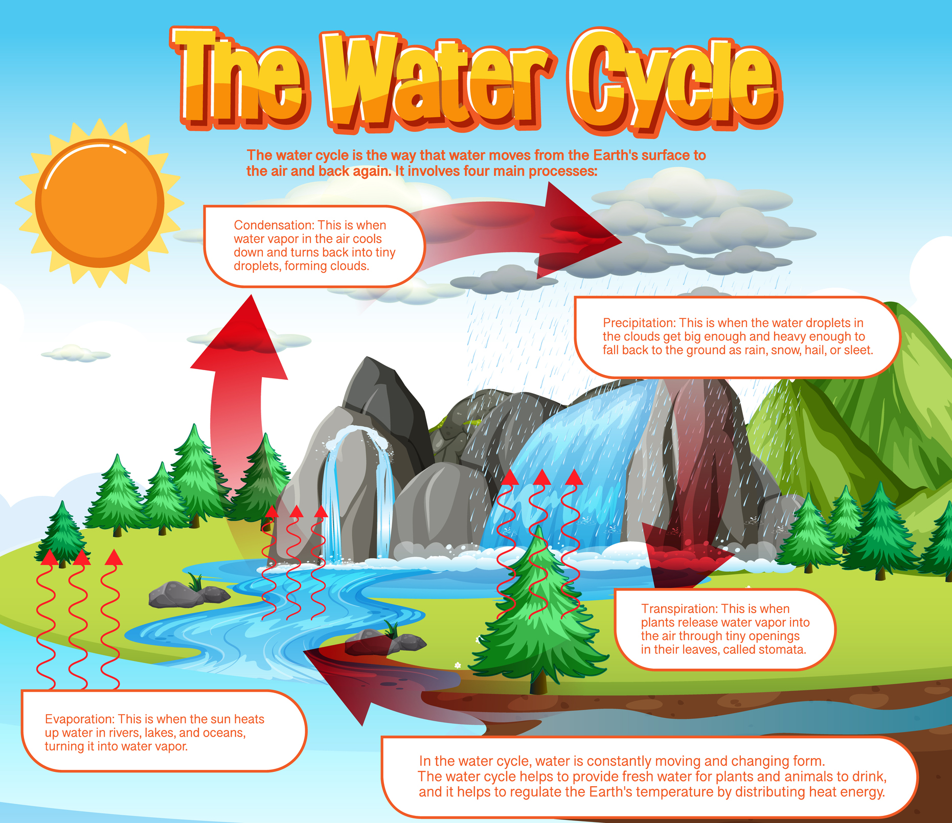
Water is constantly cycled through our environment.
Some of the rain runs across the Earth’s surface into creeks and rivers and from there into lakes and dams. This water is called surface water. Some of the water soaks into the ground and collects in the cracks and crevices there. This water is called ground water. Ground water feeds underground streams and aquifers. It is often pumped back up to the surface through bores and is an important source of water for industry, agriculture and domestic homes and gardens. Surface water and ground water are the two main sources of water for use in Australian homes and schools.
On this page:
- Browse these tabs to learn about powerful scientific ideas in earth and space sciences.
Weathering and erosion
The surface of the Earth is constantly changing. Land is being uplifted through processes such as plate tectonics and volcanic activity. Landforms are then further shaped through the processes of weathering and erosion.
As matter cannot be created or destroyed, the matter in rocks must be constantly cycled.
Weathering
Weathering is the process by which rocks are chemically altered or physically broken into fragments, and involves little or no transportation of the fragments. Rocks can be weathered, for example, by ice formation in rock cavities which breaks the rock apart, and changes in temperature causing the rocks to expand and contract producing fractures.
Rocks can also be weathered through chemical processes, for example, the mild acidity of some rainfall can cause minerals in the rock to slowly dissolve. This is how caves such as the Jenolan Caves in New South Wales were formed. Acid can also be released from living things, for example, the decay of organic material, or by direct secretion of acids (lichens).
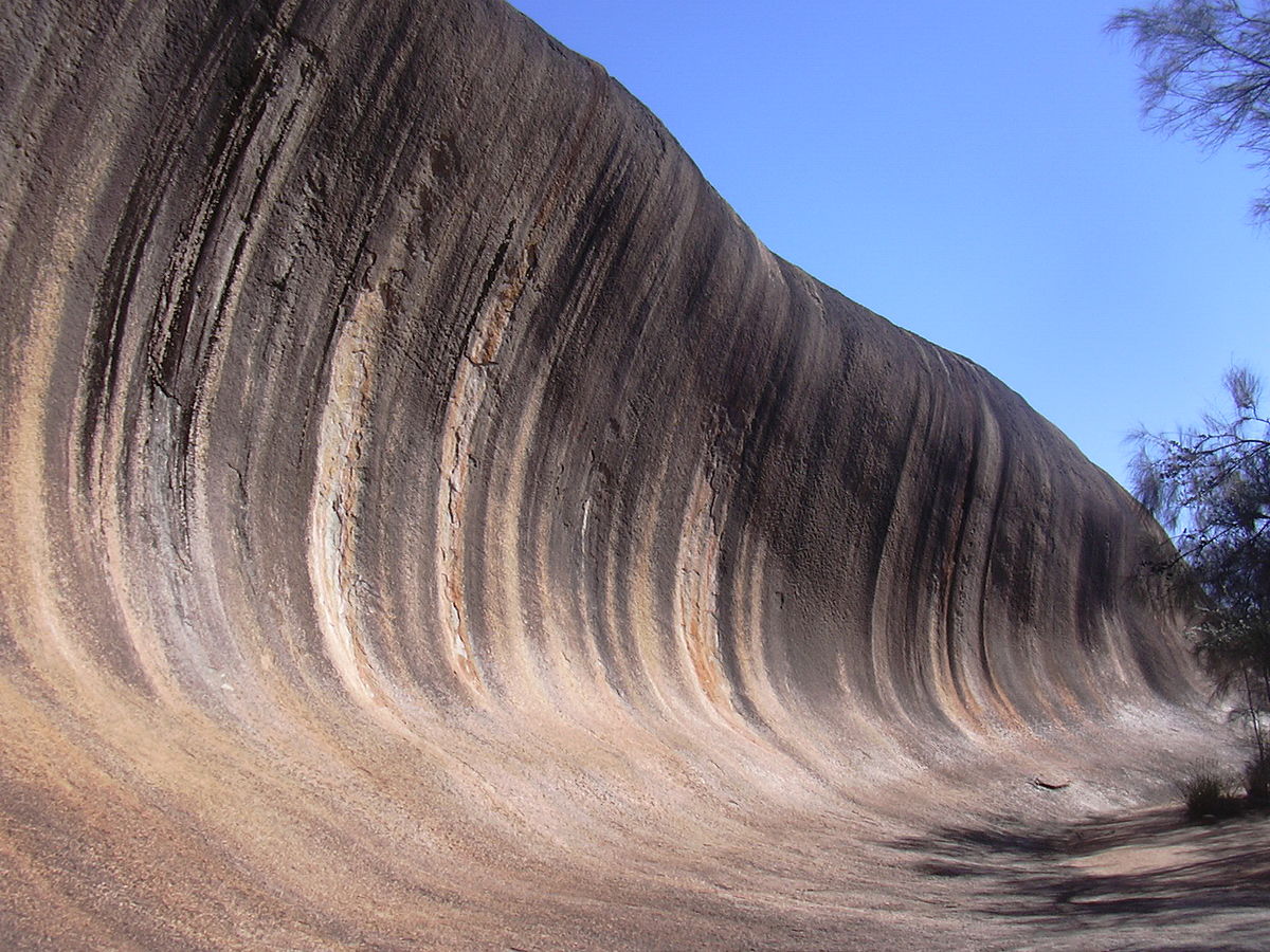
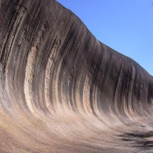
"Wave Rock (Western Australia)" by Gabriele Delhey (Wikimedia Commons) licensed under CC BY SA 3.0
This rock formation is a result of weathering by wind and sand.
The rate at which weathering occurs depends on three main factors: climate, the susceptibility of minerals to weathering and the amount of surface exposed to the atmosphere. The Devils Marbles in the Northern Territory are an example of rock bodies modified by weathering.
Erosion
Erosion is the removal and transport of rocks and weathered material, for example, soil. It helps to shape landscapes. Agents of erosion include water, ice, wind and gravity. Erosion is affected by variations in the Earth’s surface. For example, if a creek flows over a cliff, a deep pool often forms at its base because the impact of the water falling from a height causes more erosion. Once there is mild erosion, subsequent water tends to flow in the same place, creating deeper and deeper river beds. Human activity can also lead to erosion, for example, the removal of vegetation and constructions such as fences or dams affect erosion rates.
Erosion is a natural process that can be affected by human activity. Erosion, especially in Australia, is a serious concern given the slow-forming ancient soils prevalent in this country. Farmers are particularly concerned about erosion if it removes the soil required for crop growth. Living things, for example, plants both help and hinder erosion. Plant roots bind soil, reducing wind erosion, but can also help weather rocks. Farmers in windy areas often plant rows of trees between their fields. This slows down the wind at ground level, which reduces the amount of soil lost to erosion.
Trees bind soil with their roots, slowing erosion, but their roots can also assist to break up rocks. The decay of once-living things (organic matter) can cause water to become more acidic, inducing chemical weathering of rocks. Rainfall and wind corridors are in turn influenced by the landscape.
By clearing plants away and leaving soil bare after harvest, farmers can leave soils vulnerable to erosion. The top layer of the soil is the most susceptible to being blown away. This is also the richest source of nutrients for crops grown by farmers.
Transportation and deposition
Erosion takes particles away, but they are eventually deposited somewhere. Many particles end up in the sea or in lakes where they accumulate and form sediments that can eventually become new (sedimentary) rocks.
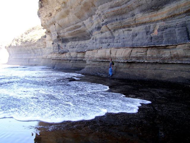
Layers of sediment can harden over a long timescale to form new rock.
Time scale of change
Many rocks take a long time to be broken down and worn away in natural conditions. However, some rocks can be weathered very quickly once they are exposed. For example, the limestone of the Twelve Apostles formation in Victoria developed around 20 million years ago on land. Between 7,000 and 10,000 years ago, at the end of the last ice age, sea levels rose and the limestone was exposed to the sea. Since then, the force of the waves has slowly weathered and eroded the cliffs to create isolated stacks of rocks. In 2005, one of the stacks collapsed, leaving eight standing. The rate of erosion at the base of the limestone stacks is approximately 2 cm per year. Due to wave action eroding the cliff face, existing headlands are expected to become new limestone stacks in the future.
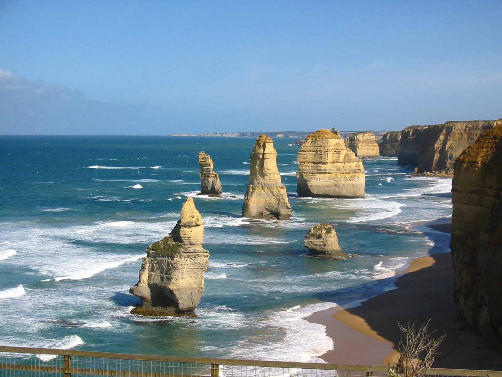 "Apostel Panorama" by Paul Haydock-Wilson | 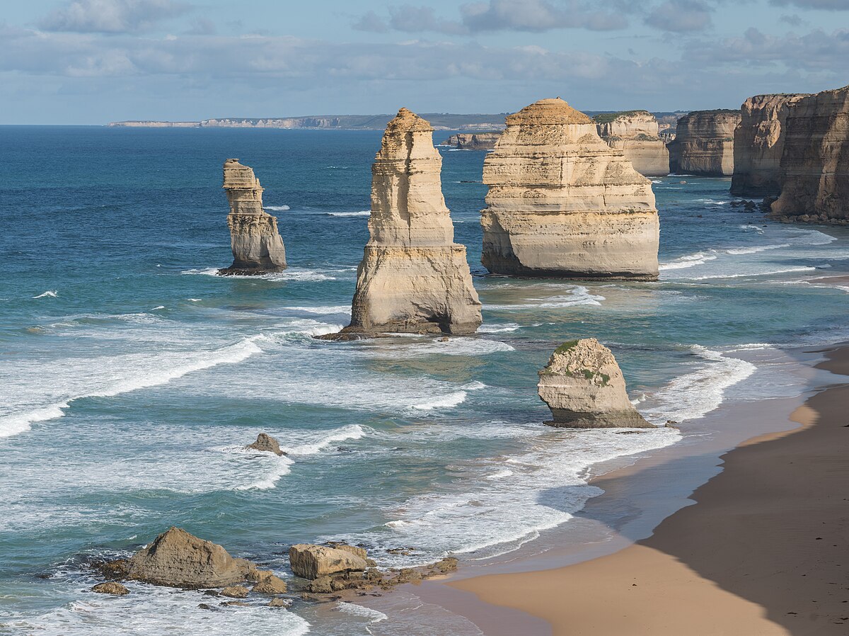 "Twelve Apostles, East view" by Daniel 'DXR' (Wikimedia Commons) licensed under CC BY SA 3.0 |
The creation of soils can take hundreds of years, but the erosion of soils can happen very quickly. For example, a mound of loose soil on a hill can be destabilised by water or by vibrations from an earthquake. The hillside might then suddenly collapse due to gravity. The presence of plants such as trees provides a buffer against wind, and all plant roots can help bind soil, reducing the amount blown or washed away.
On this page:
- Browse these tabs to learn about powerful scientific ideas in earth and space sciences.
The Earth system comprises dynamic and interdependent systems; interactions between these systems cause continuous change over a range of scales.
This list of alternative conceptions is not meant to be comprehensive, but instead aims to provide a starting point.
Alternative conception | Accepted conception |
| The particles in the air are not moving. | Air is made up of gas particles that are constantly moving (have kinetic energy). |
| When water in a container evaporates, the water has soaked into the container. | Liquid water evaporates and becomes water vapour in the air. |
| Boiling water makes steam which becomes clouds. The Sun boils the sea to make clouds. | Liquid water evaporates and becomes water vapour in the air. As the water vapour cools, it condenses into small collections of liquid water (clouds). |
| Thunder is because of God(s)/angels/bowling balls in the sky. | The moving air/clouds cause a separation of charged particles in the sky (static electricity). Lightning is the spark of electricity that allows the charges to move together. This rapidly heats and expands the air causing thunder. |
| We sweat more on a humid day. | Less water evaporates on a humid day. |
| Rain is caused by clouds being too full of water or bursting. Rain comes from holes in the clouds. | As water vapour cools, it condenses into water droplets that combine and become a drop. When the air is saturated, rain will fall. |
| Soil has always been present. | Soil is the product of weathering, erosion and decomposition. |
| Soil is made up of dead things. | Soil is the product of weathering, erosion and decomposition. |
| Rocks are always heavy. | Some rocks (pumice) contain pockets of air. |
| Mountains and valleys have always been present. | Mountains and valleys are formed by a combination of tectonic plate movement, volcanoes, weathering, erosion and deposition. |
| Volcanic lava comes from the centre of the earth. | The centre of the earth is solid surrounded by molten magma. When magma leaves the earth’s surface it is called lava. |
| The greenhouse effect is bad. | The greenhouse effect traps heat in the atmosphere and helps us avoid the extremes of temperatures that occurs on the Moon or in space. |
| It is hotter in the city this summer and that is global warming. | Global warming is measured over large areas (Earth) and time scales (many years) to show the trend. |
| The atmosphere is oxygen and carbon dioxide. | The atmosphere is a mixture of gases including 78% nitrogen. |
References
AITSL. (n.d.). Resource. AITSL. https://www.aitsl.edu.au/tools-resources/resource/dispelling-scientific-misconceptions-illustration-of-practice
Allen, M. (2019). Misconceptions in Primary Science 3e. McGraw-hill education (UK).
Ideas for Teaching Science: Years 5-10. (2014, April 14). Resources for Teaching Science. https://blogs.deakin.edu.au/sci-enviro-ed/years-5-10/
Pine, K., Messer, D., & St. John, K. (2001). Children's misconceptions in primary science: A survey of teachers' views. Research in Science & Technological Education, 19(1), 79-96.
Redhead, K. (2018). Common Misconceptions. Primary Science Teaching Trust. https://pstt.org.uk/resources/common-misconceptions/
University of California. (2022, April 21). Correcting misconceptions - Understanding Science. Understanding Science - How Science REALLY Works... https://undsci.berkeley.edu/for-educators/prepare-and-plan/correcting-misconceptions/
On this page:
- Browse these tabs to learn about powerful scientific ideas in earth and space sciences.